Official Name:
永丰乡烽火台YongFengXiangFengHuoTaiOur Name:
十二师西山农牧场烽火台 / ShiErShiXiShanNongMuChangFengHuoTai
Other Name:
/
Period:唐 / Tang Dynasty 618~907
Location: 新疆维吾尔自治区,乌鲁木齐市,乌鲁木齐县,乌鲁木齐市乌鲁木齐县永丰乡永丰村一队北1.6千米 / XinJiangWeiWuErZiZhiQu,WuLuMuQiShi,WuLuMuQiXian,WuLuMuQiShiWuLuMuQiXianYongFengXiangYongFengCunYiDuiBei16QianMi
[
Looking Local List]
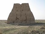
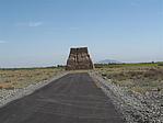
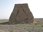
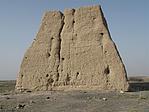
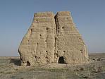
Details:长城类别:单体建筑
经纬高度:东经:087° 22′ 北纬:43° 36′ 海拔:1388
建筑形式:
材料:由黄土夯筑而成,夯土中见有小碎石�
附近遗存:东距乌拉泊村烽火台25千米。
Type:烽火台 Beacon Tower
Protection Level:县保
Content:
Memo:
Other Records:
Distribution:
visit location in Tianditu Map[recommend] Distribution:
visit location in Tencent QQ Map Distribution:
visit location in Google MapDistribution:
visit location in Baidu MapNational ID:650121353201120001
The original number submitted by the local government :650121353201180001
(when the Great Wall is identified, the data whose code has been adjusted will display the original number submitted by the local government before revision, which can be used by the local cultural relics department when checking the local data.)
Action:[
 Save in Data Basket
 ]
Picture:
Click the thumbnail to view the Big Pic. Click the Big Pic to Hide the Big Pic![Caption:永丰乡烽火台
loading images --Please wait...]()
![Caption:永丰乡烽火台
loading images --Please wait...]()
![Caption:永丰乡烽火台
loading images --Please wait...]()
![Caption:永丰乡烽火台
loading images --Please wait...]()
![Caption:永丰乡烽火台
loading images --Please wait...]() Photo Links
Photo Links:
 Search ::
  Favorite/My Favorite :: Recent Changes :: :: Login