Official Name:
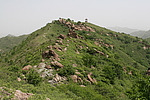
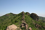
刘家沟长城LiuJiaGouChangChengOur Name:
/
Other Name:
/
Period:明 / Ming Dynasty 1368~1644
Location: 锦州市,凌海市,起点:翠岩镇刘家沟村(东1100米鸡冠山上)止点:翠岩镇郭荒地村(东650米大青山上) / JinZhouShi,LingHaiShi,QiDianCuiYanZhenLiuJiaGouCun(Dong1100MiJiGuanShanShang)ZhiDianCuiYanZhenGuoHuangDiCun(Dong650MiDaQingShanShang)
[
Looking Local List]
Details:长城类别:墙体
起点经纬高度:东经:121° 2′ 北纬:41° 11′ 海拔:277
终点经纬高度:东经:121° 1′ 北纬:41° 9′ 海拔:300
墙体走向:墙体大体呈西北-东南转西南转东南转西南转西转南转西南走向。该段长城山险墙起自翠岩镇刘家沟村(东1100米鸡冠山上),一路自西北向东南转西南沿山脊呈上行走势,墙体从敌台西侧3米处通过,止于翠岩镇郭荒地村(东650米大青山上)。
墙体类别:山险墙
结构特点及构筑方式:剖面呈不规则形。该段墙体基础为自然山体岩石基础,山体低洼处用毛石垒筑。此段墙体人工砌筑部分底宽1-2米,顶宽0.5-1米,残高0.5-1.5米。
现状:山险墙。
Type:山险墙 Precipitous mountain areas as wall
Protection Level:无
Content:
Memo:
Other Records:
Distribution:
visit location in Tianditu Map[recommend] Distribution:
visit location in Tencent QQ Map Distribution:
visit location in Google MapDistribution:
visit location in Baidu MapNational ID:210781382105170016
Action:[
 Save in Data Basket
 ]
Picture:
Click the thumbnail to view the Big Pic. Click the Big Pic to Hide the Big Pic![Caption:刘家沟长城
loading images --Please wait...]()
![Caption:刘家沟长城
loading images --Please wait...]() Photo Links
Photo Links:
 Search ::
  Favorite/My Favorite :: Recent Changes :: :: Login